Organisation

Organisation
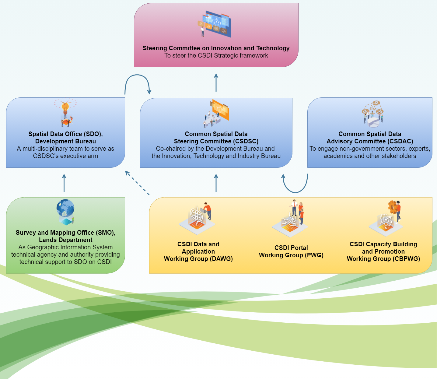
The Steering Committee on Innovation and Technology (SCIT) is responsible for steering the CSDI Strategic framework. The Common Spatial Data Steering Committee (CSDSC), co-chaired by the Development Bureau (DEVB) and the Innovation, Technology and Industry Bureau, which serves as the key body for providing CSDI policy under the steering of SCIT. Spatial Data Office (SDO), is a multi-disciplinary team under the DEVB to serve as CSDSC’s executive arm. The Common Spatial Data Advisory Committee (CSDAC), is set-up to engage non-government sectors, experts, academics and other stakeholders, to advise the Government on the development of CSDI through CSDSC. Three working groups, the CSDI Data and Application Working Group (DAWG), the CSDI Portal Working Group (PWG) and the CSDI Capacity Building and Promotion Working Group (CBPWG), are set-up for proposing strategies, plans, programmes and initiatives for CSDSC’s review and approval. Survey and Mapping Office (SMO) under Lands Department is the Geographic Information System technical agency and authority, providing technical support to SDO on CSDI.

Objectives of Spatial Data Office (SDO)

  • To draft and propose detailed policies/ strategies/ action plans/ initiatives and the corresponding Key Performance Indicators (KPIs) on CSDI and spatial data sharing;
  • To formulate and promulgate standards, guidelines best practices and toolkits relating to CSDI and spatial data sharing at the central level and liaising with departments about CSDI implementation; to monitor the current state of compliance of common standards and content-specific standards;
  • To provide the institutional structure for data sharing, discovery and access; to stock take metadata and prepare metadata inventory for spatial data particularly in the area of planning, lands and works (PLW); and non-PLW data that are necessary for the work of PLW agencies;
  • To identify and prioritise fundamental data and common sharable data for coordinated development, maintenance and dissemination; to request Bureaux/ Departments (B/Ds) to spatially enable non-sensitive location-related data identified as fundamental data or common sharable data;
  • To formulate strategy and monitor the implementation of capacity building plan and outreach the stakeholders with engagement plan on a regular basis;
  • To collaborate with external parties in implementing CSDI and spatial data sharing; to enhance public education and community involvement in CSDI and spatial data sharing; to address liability concerns of data providers, disclaimers and terms of services; and
  • To liaise with local and overseas institutions or organisations on the latest developments of CSDI; to conduct research on overseas legislation, practices, etc. on CSDI and see how they can be applied in the Hong Kong context.